Map data·6 min read
US Congressional Districts Explained: 435 Votes, 441 Shapes
A congressional district is the area that elects one member of the House. There are 435 with a vote on the floor, and 441 shapes in the boundary file. Both numbers are right, and knowing which one you are looking at saves an hour of reconciling a spreadsheet.
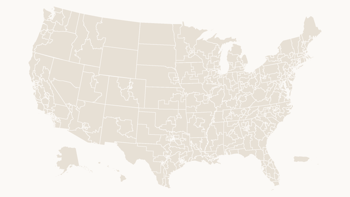
The United States is divided into 435 congressional districts, each electing one voting member of the House of Representatives. The District of Columbia, Puerto Rico, Guam, American Samoa, the Northern Mariana Islands and the Virgin Islands are not part of a state, so each gets one non-voting delegate instead — six more shapes, and 441 features in the Census Bureau cartographic boundary file for the 119th Congress.
Which number you use depends on the question. For apportionment, elections and anything a roll-call vote touches, it is 435. For anything drawn on a map — "shade every district", "label every district" — it is 441, because a delegate district has a boundary too, and it lives in the same file under the same schema.
Where 441 comes from, and why 435 is still correct
The file does not label districts as voting or non-voting. It encodes the difference in LSAD, the legal/statistical area code, and the four values it uses are enough to reconstruct the arithmetic:
| What it is | LSAD | Shapes | Votes on the floor |
|---|---|---|---|
| Numbered district | C2 | 429 | Yes |
| At-large district, single-district state | C1 | 6 | Yes |
| Delegate district (DC, AS, GU, MP, VI) | C4 | 5 | No |
| Resident Commissioner district (PR) | C3 | 1 | No |
| Total | 441 | 435 voting |
429 numbered plus 6 at-large is the 435. The other six are the ones that show up in a chamber count as "delegates", and they are the reason a table of 435 districts joined to a 441-row file leaves six unmatched rows — usually the six at the bottom of the alphabetical list, which is why they are easy to blame on a bad join.
A district is not guaranteed to be one connected piece of ground, and a state is not guaranteed to have more than one district. Nothing in the schema flags either case. You find both by counting rows, which is what the code further down does.
The GEOID is four digits, and the first two belong to the state
A district carries the same property set as every other Census boundary: STATEFP is the two-digit state FIPS code, CD119FP is the district code within that state, and GEOID is the two concatenated.
Take the third district of California:
STATEFP 06      CD119FP 03      GEOID 0603
GEOIDFQ 5001900US0603           NAMELSAD "Congressional District 3"
That is one digit shorter than the five-digit county GEOID, which is the first thing to trip up a join built for counties — the two are not interchangeable, and the anatomy of both codes is worth ten minutes before you merge anything. The second trap is quieter: NAMELSAD contains no state name. Congressional District 3 is the label on 37 different shapes in this file, so a legend, a slide title or a tooltip generated from that field alone will name the wrong state 36 times out of 37.
Two district codes are not district numbers at all. 00 marks a state small enough to elect its member statewide, and 98 marks a delegate or resident commissioner area. Both still produce a valid four-digit GEOID, which is exactly why they survive a validation check that only tests "is this four digits".
Six states get one shape and no number
Six states have a delegation of one. Their shapes carry CD119FP 00, and their NAMELSAD is identical across all six: Congressional District (at Large). Sort the file by name and a label rule reading NAMELSAD produces six slides with the same title.
| GEOID | State | Land area (km²) | Polygons in the shape |
|---|---|---|---|
0200 | Alaska | 1,479,893 | 139 |
5600 | Wyoming | 251,458 | 1 |
4600 | South Dakota | 196,342 | 1 |
3800 | North Dakota | 178,694 | 1 |
5000 | Vermont | 23,873 | 1 |
1000 | Delaware | 5,047 | 2 |
Delaware having two polygons is not an error: the second piece is a small island. It is also the shape of a problem you will meet again below — a district is a set of polygons, not a polygon.
A district number is a label, not a location
Nothing in the numbering says where a district sits. California's 3rd is not next to its 2nd, and the sequence does not run north to south, west to east, or by population. The numbers are assigned by each state's own map, redrawn after every census, so 0603 identifies a shape for the life of one redistricting cycle and then possibly a different patch of ground for the next.
What the numbers do not tell you is also what makes them useful as keys. Measure the shapes and the spread is enormous:
| District | GEOID | Land area |
|---|---|---|
| Alaska, at large | 0200 | 1,479,893 km² |
| Montana 2nd | 3002 | 272,940 km² |
| Median numbered district | — | 5,235 km² |
| New York 12th | 3612 | 24.8 km² |
The largest shape in the file is 5.4 times the largest numbered district and roughly 59,700 times the smallest. Shade by land area and the map becomes a picture of the West, which is why area belongs in the file and population belongs in your spreadsheet. The five-class ramp that holds up on a projector assumes the numbers behind it mean something; district area usually does not.
58 of the 441 are more than one polygon
Geometry type is the field to check before you promise anyone a click-per-district workflow. In this file 383 districts are a single Polygon and 58 are a MultiPolygon. Alaska at large leads with 139 separate pieces, the Aleutians being the reason; Michigan's 1st has 19, Wisconsin's 7th 15, the Northern Mariana Islands delegate 15, and Washington's 2nd 12.
California accounts for 8 of the 58, Florida and New York 5 each, Washington 4, Illinois 3. These are coastal and island districts, and each one is a set of shapes that must be filled as a set. Click the mainland, apply a color, and the islands stay whatever color they were — the classic half-shaded district that nobody notices until it is projected.
The fix is structural rather than cosmetic: group the district's pieces into one object before filling, so a fill applies to all of them at once. Grouping before coloring is also what keeps a district moving as one piece when the slide gets rearranged. The national district template ships with that already done, which is the only real difference between it and a file you assemble from raw boundaries.
The file has no party, no name, no result
Nine properties come with each district: STATEFP, CD119FP, GEOIDFQ, GEOID, NAMELSAD, LSAD, CDSESSN, ALAND, AWATER. There is no incumbent, no party, no margin, no population and no competitiveness rating. A party-colored map is your data joined to these shapes, not something the shapes know.
That join is the whole job, and it needs three rules:
- Join on
GEOID, never onNAMELSAD. The name is not unique across states, and for six states it is not unique across the map. - Normalize the string.
0603is text. Open the CSV in a spreadsheet and the leading zero is gone, turning California's 3rd into603and quietly matching nothing. - Give the six non-voting rows a home. Results tables usually list 435 races. The five delegates and the resident commissioner are reported separately, or not at all — decide which, and do not let them fall into a "no data" class that reads as a real value.
State-level detail is easier than national when you are checking a single delegation: a California district map carries the 52 shapes and their GEOIDs without the other 389, so a mismatch shows up in one state instead of in a national total.
Counting it yourself
Every number above comes out of the file, and the counts are four lines of Python away:
import collections
import json

features = json.load(open("data/cd119.geojson", encoding="utf-8"))["features"]
kinds = collections.Counter(f["properties"]["LSAD"] for f in features)
print(len(features), "features")
print(kinds["C2"], "numbered", kinds["C1"], "at-large",
      kinds["C3"] + kinds["C4"], "non-voting")

seats = collections.Counter(f["properties"]["STATEFP"] for f in features)
print(seats.most_common(4))
441 features
429 numbered 6 at-large 6 non-voting
[('06', 52), ('48', 38), ('12', 28), ('36', 26)]The delegation sizes are worth a second look, because they are the numbers people quote when they talk about the House rather than about a map:
| State | Districts | State | Districts |
|---|---|---|---|
| California | 52 | Pennsylvania | 17 |
| Texas | 38 | Illinois | 17 |
| Florida | 28 | Ohio | 15 |
| New York | 26 | Georgia | 14 |
Six states hold 178 of the 435 seats — California, Texas, Florida, New York, Pennsylvania and Illinois — and six states hold one each. That asymmetry is the reason a district map at national scale is a poor way to show per-seat data in the small states: Rhode Island's two districts cover 694 km² and 1,984 km², less ground than a single Alaska borough, and at slide scale they are two slivers.
How many congressional districts are there in the United States?
Which states have only one congressional district?
Does a congressional district have a FIPS code?
Why do the delegate districts end in 98?
441 districts, already separated
Every district of the 119th Congress as its own fillable shape, with the GEOID printed on the reference slide so a results table joins without guessing. $9.99, one-time download.
See the district mapQuestions
How many congressional districts are there in the United States?
Which states have only one congressional district?
Does a congressional district have a FIPS code?
Why do the delegate districts end in 98?
Written in-house. Boundary counts are checked against the published files, and every figure on this page can be reproduced from the source named in it.